
Keyword
Earth Science | Oceans | Salinity/Density
7 record(s)
Type of resources
Topics
Keywords
Contact for the resource
Provided by
Formats
Update frequencies
Status
draft
-

DEPRECATED: This dataset has been superseded by GBR4_H2p0. It will be decommissioned in April 2024. Results from version 1.85 of the 4 km resolution regional-scale hydrodynamic model of the great Barrier Reef (GBR4). It was forced with BlueLink OceanMAPS data on the open boundaries and Bureau of Meteorology model ACCESS-R for surface atmospheric data. The tide was introduced through 22 constituents derived from the global CSR tide model, and 22 river boundaries incorporated measured stream flow and temperature data from QLD DNRM's gauging stations. This model version was published for reference in the SIEF report from January 2016, but was later discovered to have been forced with incorrect (multiplicative error) rainfall levels, and the 2015 results contain salinity errors. This model configuration and associated results dataset may be referred to as "GBR4_H1p85" according to the eReefs simulation naming protocol.
-

DEPRECATED: This dataset has been superseded by GBR1_H2p0 and it will be decommissioned in April 2024. Results from an early version of the 1km-resolution shelf-scale hydrodynamic model of the Great Barrier Reef (GBR1). This version of the model was forced by version 1.85 of the eReefs GBR 4 km resolution hydrodynamic model, and the results were made available for comparison purposes only. This model configuration and associated results dataset may be referred to as "GBR1_H1p71" according to the eReefs simulation naming protocol.
-
This record describes expendable bathythermograph (XBT) and expendable conductivity-temperature-depth profiler (XCTD) data collected on the Japanese deep-sea research vessel Kairei voyage KR16-LHR, titled '2016FY Acquisition of deep seismic, shallow sub-surface and seafloor bathymetry Survey Data for the Lord Howe Rise (MCS, OBS).' The vessel conducted marine scientific research in the Australian EEZ between 23 March and 11 May 2016. The survey consisted of three legs: Leg1: 23 March - 30 March, Brisbane (QLD) to Brisbane Leg2: 2 April - 20 April, Brisbane to Brisbane Leg3: 22 April - 11 May, Brisbane to Brisbane A total of 1 XBT and 4 XCTD casts were conducted over the duration of this voyage: Type / Date / Time (UTC) / Latitude / Longitude / Type XBT T05 / 20160324 / 180644 / 27o22.9720S / 162o26.4646E XCTD CT2 / 20160402 / 224128 / 27o13.0832S / 155o33.4541E XCTD CT2 / 20160408 / 120230 / 27o23.0842S / 161o34.4947E XCTD CT2 / 20160415 / 022902 / 27o31.1244S / 160o10.1520E XCTD CT2 / 20160425 / 023019 / 26o25.6134S / 161o14.2481E Data are stored in ASCII and comma-separated files at CSIRO. Profile plots in PDF format are also part of the dataset. Additional information regarding this dataset is contained in the cruise summary report (see link below).
-
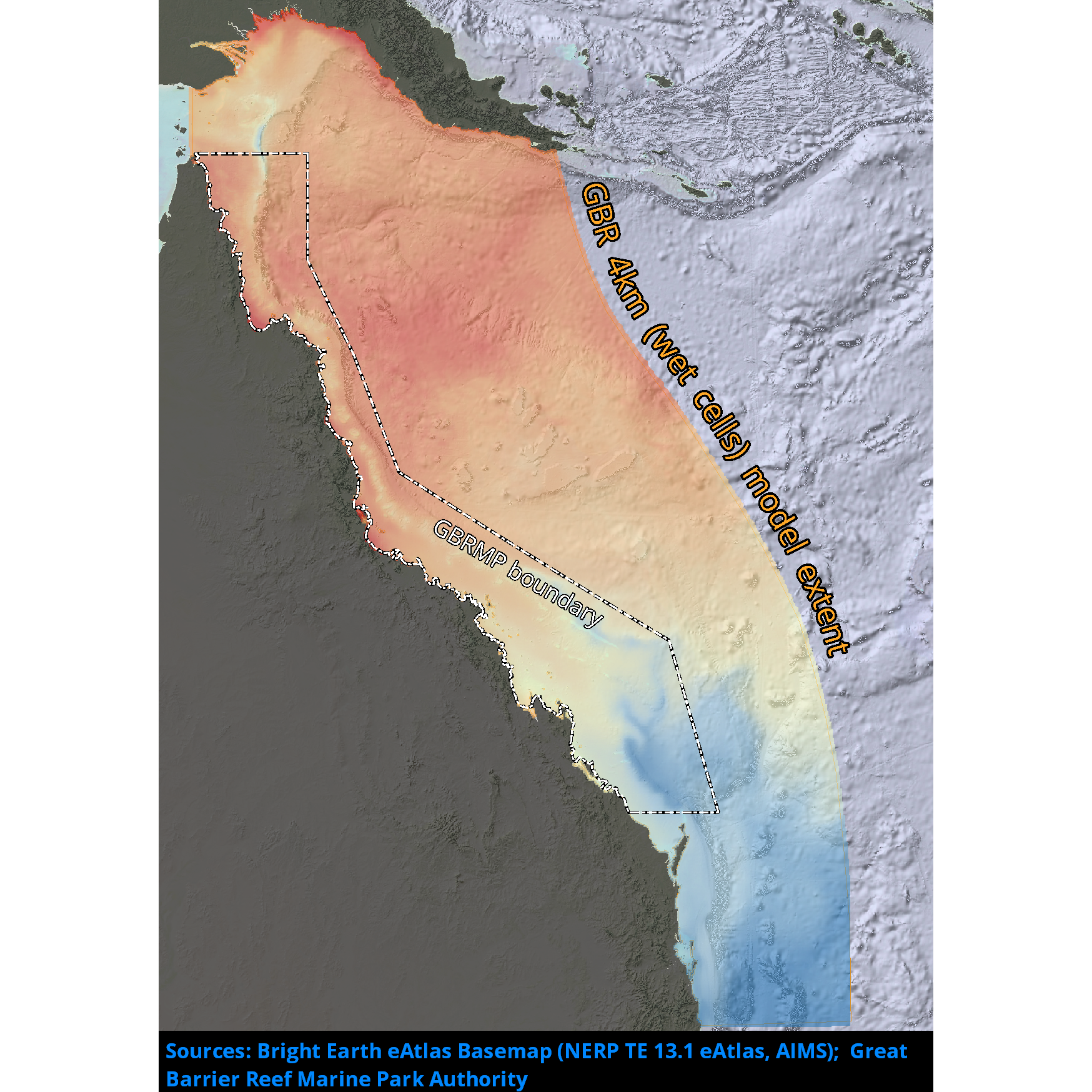
Results from version 2.0 of the 4km-resolution regional-scale hydrodynamic model of the Great Barrier Reef (GBR4). This model is forced with BlueLink Ocean Modelling and Prediction System (OceanMAPS) model results on the ocean boundaries and Bureau of Meteorology ACCESS-R model for surface atmospheric data. The tide is introduced through 22 constituents derived from the global CSR tide model, and the river boundaries incorporate measured stream flow and temperature data from QLD DNRM's gauging stations for 22 rivers, and estimated flows and loads for 49 additional rivers. There are no known forcing problems. This model configuration and associated results dataset may be referred to as "GBR4_H2p0" according to the eReefs simulation naming protocol. The model runs in near-real-time mode, updating daily.
-
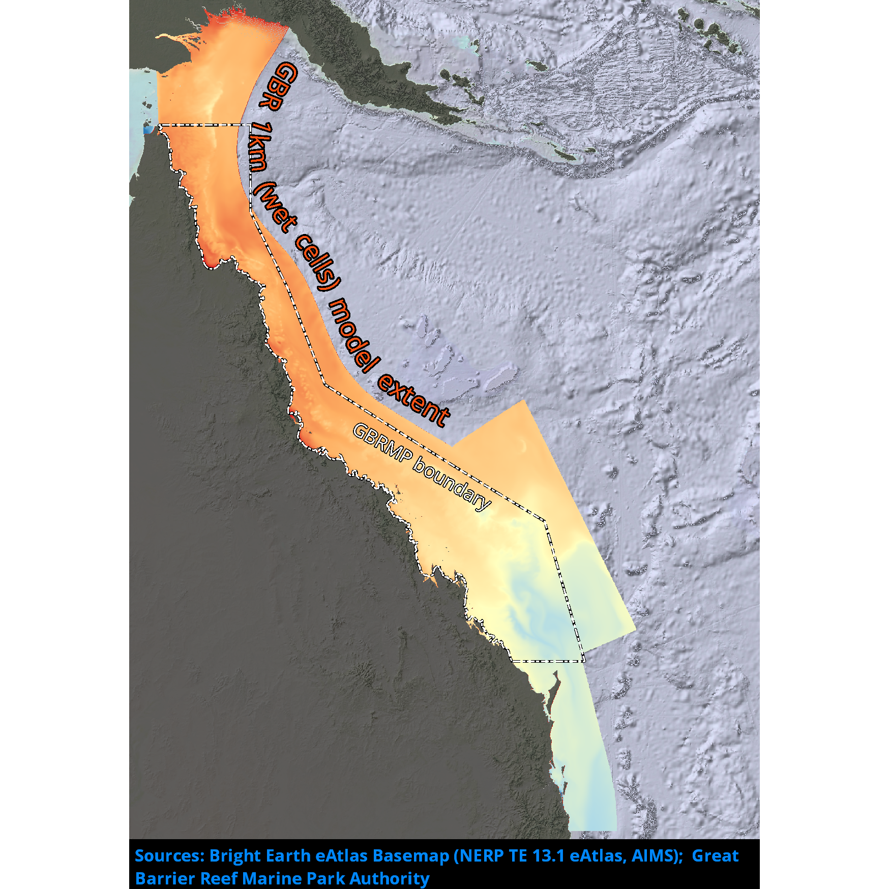
Results from version 2.0 of the 1km-resolution shelf-scale hydrodynamic model of the Great Barrier Reef (GBR1). This model is nested within version 2.0 of the 4km-resolution hydrodynamic model (GBR4) data at the ocean boundaries, uses the Bureau of Meteorology ACCESS-R model for surface atmospheric data and incorporates measured flow data from gauging stations at the river boundaries from QLD DNRM. This model configuration and associated results dataset may be referred to as "GBR1_H2p0" according to the eReefs simulation naming protocol. The model runs in near-real-time mode, updating daily.
-
This record describes the Conductivity-Temperature-Depth (CTD) data collected from the Marine National Facility RV Investigator Voyage IN2017_V05, titled: Long-term recovery of trawled marine communities 25 years after the world’s largest adaptive management experiment. The voyage took place between October 11 and November 10, 2017 departing from Broome (WA) and arriving in Fremantle (WA). Data for 72 deployments were acquired using the Seabird SBE911 CTD unit 23, fitted with 36 twelve litre bottles on the rosette sampler. Sea-Bird-supplied calibration factors were used to compute the pressures and preliminary conductivity values. CSIRO -supplied calibrations were applied to the temperature data. The data were subjected to automated QC to remove spikes and out -of-range values. The final conductivity calibration was based on a single deployment grouping. The final calibration from the primary sensor had a standard deviation (S.D) of 0.0012983 PSU, within our target of 'better than 0.002 PSU'. The standard product of 1dbar binned averaged were produced using data from the primary sensors. The dissolved oxygen data calibration fit had a S.D. of 0.6416µM. The agreement between the CTD and bottle data was good. The Biospherical photosynthetically active radiation (PAR), C-Star transmissometer, Aqua tracker Flurometer, ISUS Nitrate sensors were also installed on the auxiliary A/D channels of the CTD. Along with a Wetlabs Eco-triplet and a particle size analyser.
-
This record describes the End of Voyage (EOV) archive from the Marine National Facility RV Investigator research voyage in2016_v03, titled "Monitoring Ocean Change and Variability along 170 W from the ice edge to the equator." The voyage consisted of two legs: Leg 1 from Hobart (TAS) to Wellington (NZ) between April 27 and May 26, and Leg 2 from Wellington (NZ) to Lautoka (Fiji) from April 27 to June 28, 2016. Main project: "Monitoring Ocean Change and Variability along 170oW from the ice edge to the equator." Supplementary project: "Facing the challenges of under-ice for autonomous navigation." For further information refer to the Voyage documentation links below. Data collected include: Acoustic Doppler Current Profiler (ADCP; 75, 150 KHz and LADCP), Scanning Mobility Particle Sizers (SMPS), Disdrometer, Oxygen, Radon, and Greenhouse (Aerodyne and Picarro) sensors, CTD, Hydrochemistry, Gravitometer, Fisheries Echosounder (EK60), Multibeam Echosounder (EM122, EM710, SBP120), Weather Radar, XBT. Voyage-specific data include: Sea-ice measurements, Aerosol Chemical Speciation Monitor (ACSM), Aerosol Aerodynamic Particle sizer (APS), Carbon sensor, Cloud Condensation Nuclei counter (CCN), Chlorofluorocarbons/Sulfur Hexafluoride/Nitrogen Oxides sensor(CFC SF6 Nox), Turbulence Chipods, Condensation Particle counter (CPC), Micro Rain Radar (MRR), Microwave Radiometer (MWR), Neutral cluster Air Ion Spectrometer (NAIS), Proton-transfer-reaction mass spectrometer (PTR-MS), FOG-based High-performance Inertial Navigation System (PHINS INS), Volatile Organic Compounds (VOC) sensor, Gas Chromatograph (SEQ), Volatility-Hygroscopicity Tandem Differential Mobility Analyser (VHTDMA). The archive for the IN2016_V03 EOV data is curated by the CSIRO Oceans and Atmosphere Data Centre in Hobart, with a permanent archive at the CSIRO Data Access Portal (DAP, https://data.csiro.au/dap/), providing access to participants and processors of the data collected in the Marine National Facility RV Investigator IN2016_V03 voyage. All voyage documentation is available electronically to MNF support via the local network. Access to voyage documentation for non-CSIRO participants can be made via DataLibrariansOAMNF@csiro.au. All processed data from this voyage are made publicly available through the MNF Data Trawler (in the related links).